Eagle Rock Loop Trail is the longest loop trail in the state of Arkansas. This is the southern part of the Ouachita National Forest. The closest city is Glenwood and the trail is a 26.8 mile loop. Skill level comes in as strenuous....well we will discuss that a little later my friends. Local contacts are Albert Pike Recreation area. Yes it might sound familiar if you watch the news. This is where 20 people lost their lives due to flash floods on Friday June 11th. We were very fortunate that our trip was 3 weeks earlier on May 22nd - 24th. We had been told by the forest service that the area flash floods very easily but I don't think they had even seen one like this. I know that I have a new perspective on flash floods and backpacking and will always keep this in the back of my mind as we camped right next to the river both nights.

Ryan at the trail head.
Yes I had this same look on the last trip when I didn't know what was ahead! mmmhahahah
A bit of advise that we heeded from another trail report was to wear your Teva's the first 4 miles. Well I am very happy that we listened. I lost count of how many times we crossed the river over the first 4 miles of this trail. My feet looked like I was 90 years old they were so wrinkled from the water but it was not unwelcome in the 90 degree heat.
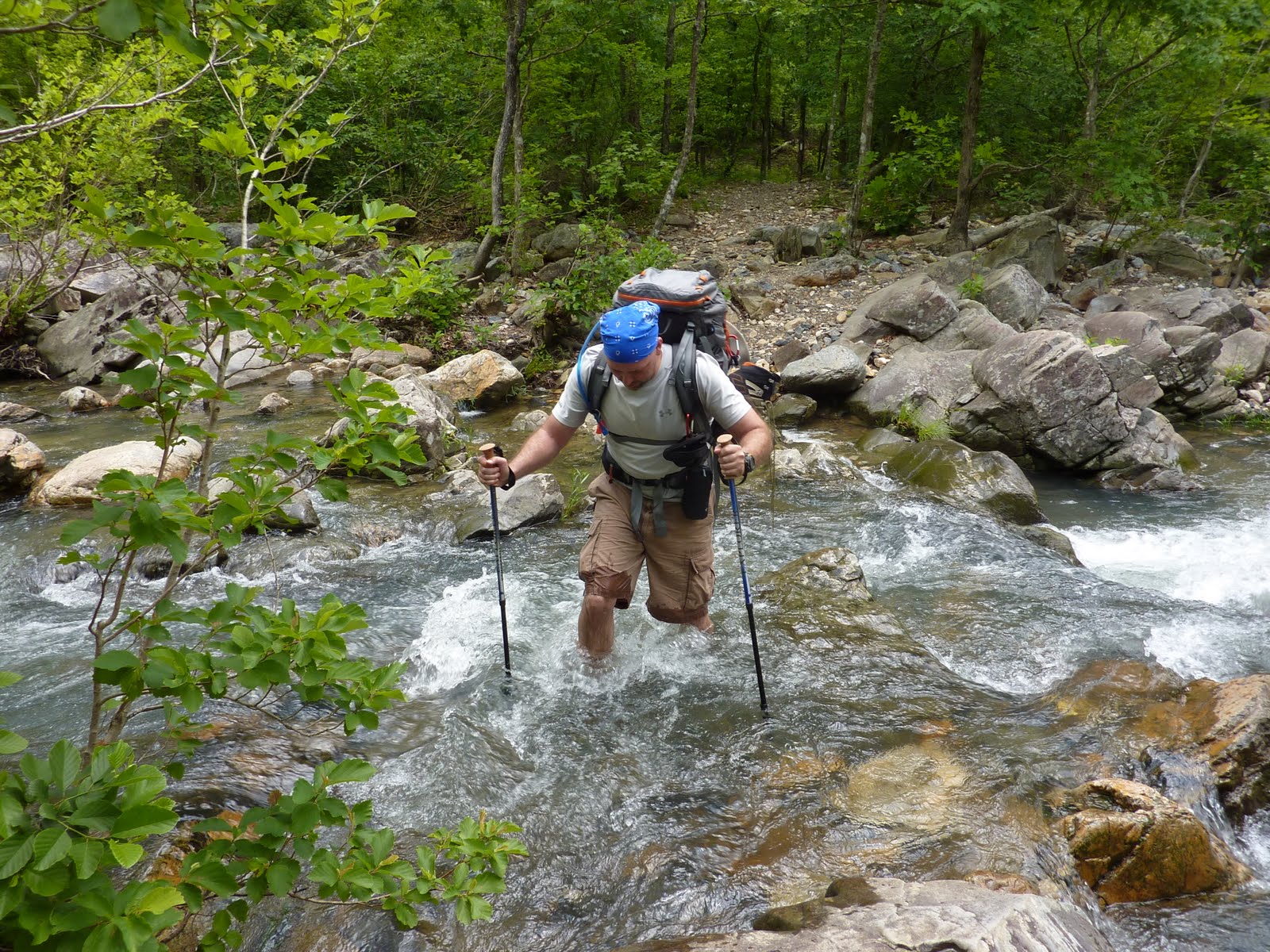
Me crossing the river - only one of many many crossing!
Day 1 - Let me tell you friends, the air temp might have been in the low 90's but the water temp was not. I found out just how cold it was when one crossing was crotch deep! I think I looked like I had the mumps for a good 10 minutes. I lost count of how many river crossing there were but they ranged from the crotch episode to simple rock hops.

Ryan - "um I got this far without getting wet...now what!"
One great thing about so many rock crossings is that you do not have to carry as much water so you are able to keep your load lighter. I packed in at about 25lbs and Ryan was right at 30lbs. He typically carried more water at a time. I think he might have had tiny pin holes in him as much as that boy sweats! He also carried the tent...hey that is what you get being a big guy! The trusty water filter did not let us down and we put it to a test in that heat. The climate ranged from near rain forest (everything constantly wet in the valleys) to near alpine on the peaks.

Wow look at that...wait, what we have to cross that tomorrow?
The first 4 miles fooled us into thinking this trail was really easy. It was very flat and easy. Ahhh that changed toward the end of the first day and through the rest of the trip. We completed a little under 12 miles the first day. The last few miles were straight up and straight down. The trail developer apparently never heard of switchbacks! I will admit it right here in print, I used to grip about switchbacks. I will never do that again. When you have a 700 foot elevation gain over a short distance or even a 350 foot elevation gain over half a mile you begin to dream of switchbacks. There were a couple of sections that we would hike 20 yards and have to stop for our hearts to not beat out of our chests. Um only 8 more mountains to go and uncountable water crossings. We dropped down into the valley from that first mountain crossing and decided on a good campsite.

Home sweet home first night.
We were 20 yards or so from the river so we could go fill up the MSR Dromedary bag so we had water to cook our dehydrated meals and to make breakfast. I was looking forward to getting settled in and relaxing. Well so much for the peace of the wilderness. We ran into two scout leaders as we came into our prospective camp site. They said they had a group of boys and another scout leader that could not continue due to severe chafing. The guys were going to get their boyscout van. They were going to hike back up a service road (pseudo road that had huge mud puddles) to a parking lot and try to catch a ride back to their van. The group of scouts entered our camp and hung out for about 3 long long long hours. We were exhausted and wanted to crash so we excused ourselves thinking they would move on down the road a bit. No such luck. The two scout leaders came back in around 9 or 9:30pm and very loudly gathered everyone up. I guess they could not have packed up their gear the previous three hours so they packed up gear, shined lights in our tent and made sure everyone in shouting distance knew what they were doing. Ok ok enough about them, except this...guys you were in black bear country...take bear precautions and hang your food!
Day 2 - We woke up to another beautiful day and made a scrumptious breakfast of oatmeal and coffee. We had to force ourselves to eat the night before knowing we needed the calories but to tired to eat, well not the next morning. Well rested I was ready to eat like a fat girl at a buffet and boy was I going to need the energy. Day two held multiple mountains. We found a great camping spot (unless your in a lightening storm) at the top of one of the mountains but we needed to make our mileage so we had to skip it. It overlooked the valley and man it would have been great!

Me close to mountain top campsite day 2
Unfortunately pictures never do justice, I am much better looking than that! Just kidding, you can't really see in the picture how high up we are but we have some pretty good altitude. We saw two hikers on the way down about 10 mins. after this picture. They were coming up the opposite way. I thought for a few seconds we were about to be face to face with some critter as much bushwhacking noise as they were making!
We hiked around 11 miles the second day. We fought gnats in every valley and I think I had a hundred of the darn things fly into my eyes! I would have given a good Franklin for a head net! Ryan spotted a great campsite that we snagged for the second night. It was right next to the river and was very scenic.

Ryan looking energized at campsite 2
It was great to be so close to the water and be able to soak our dogs after a long day on the trail. The cold water was a blessing. We walked down to the water after dark for our sweet relief, we used our head laps to see, only problem was I didn't see the nice little mud bugs that happen to live in the area that we chose for a nice soak. I tell you when the first one clamped onto my toe I almost added a big brown shark to the water! We (I) decided I had enough soaking after about the 3rd or 4th time one of those little boogers clamped on.

This is right next to our campsite on Day 2
We were too tired to build a fire so we ate supper consisting of freeze dried beef stroganoff and crawled into the tent. It seemed like a warmer night and I didn't wake up cold at 3am like I did the night before.
Day 3 - We woke up early and grabbed another quick breakfast of oatmeal and coffee and packed our gear up for the last day. We figured the 3rd day should consist of some easy trail, ummm yeah, we were wrong. It never let up until we were back at the truck. We put our hiking boots on not realizing that 200 yards up the trail was a major water crossing that you had no choice but change back into water shoes.

It was wider than it looks. Really!
We hiked another several miles when we came upon a beautiful area, there was a small cave and great cliffs. We saw several alligator gar swimming up stream, they would come up out of the water feeding I guess as fish came through the current.

It was beautiful!
We still had a few river crossing left after this. I had done soooo good at the ones where we had to rock hop, well folks my luck ran out. I pushed it a little too far and tried to hop one too many times. Yep, I fell in with my hiking boots on and filled them full. Oh, only if I had take a few extra minutes to change into the Teva's! It made the last several miles rough. The terrain was too rough for the Teva's but hiking in soaking boots does not make for good foot care.

Looking at some of the area we had just hiked.
We hiked for what seemed like another 20 miles but if you count the hike from the end of the trail to the truck it was around another 6 or 7 miles bringing the total to just under 30 miles.

I thought Ryan was going to the kiss the sign!
I kind of laughed before this trip because you can call in once you complete the loop and they will put you name on the register and send you a patch for completing it. Well, I was not laughing at the end of the trial, I wanted my patch!
Well my friends, until next time....happy trails!
Please leave comments if you read the blog.
See link below for pictures.


Hey man, great post! I just sent this to some buddies of mine since we're planning a trip there this May. Question: You mentioned gnats on the trail, but how were the bugs at night? Mosquitoes?
ReplyDelete